


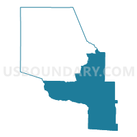
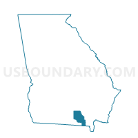
065F - FARGO Voting District, Clinch County, Georgia
About
Outline

Summary
| Unique Area Identifier | 560749 |
| Name | 065F - FARGO Voting District |
| County | Clinch County |
| State | Georgia |
| Area (square miles) | 311.56 |
| Land Area (square miles) | 305.24 |
| Water Area (square miles) | 6.32 |
| % of Land Area | 97.97 |
| % of Water Area | 2.03 |
| Latitude of the Internal Point | 30.76392030 |
| Longtitude of the Internal Point | -82.57425360 |
Maps

Graphs
Select a template below for downloading or customizing gragh for 065F - FARGO Voting District, Clinch County, Georgia


Neighbors
Neighoring Voting District (by Name) Neighboring Voting District on the Map
- 065D - DUPONT Voting District, Clinch County, GA
- 065H - HOMERVILLE Voting District, Clinch County, GA
- 1011058 - STATENVILLE Voting District, Echols County, GA
- 25-Voting District, Columbia County, FL
- 299407 - MANOR Voting District, Ware County, GA
- 4A-Voting District, Baker County, FL
Top 10 Neighboring County Subdivision (by Population) Neighboring County Subdivision on the Map
- Sanderson CCD, Baker County, FL (12,900)
- Homerville CCD, Clinch County, GA (5,239)
- North Columbia CCD, Columbia County, FL (1,761)
- East Echols CCD, Echols County, GA (1,694)
- Fargo CCD, Clinch County, GA (1,559)
- Manor CCD, Ware County, GA (789)
Top 10 Neighboring Place (by Population) Neighboring Place on the Map
Top 10 Neighboring Unified School District (by Population) Neighboring Unified School District on the Map
- Columbia County School District, FL (67,531)
- Ware County School District, GA (36,312)
- Baker County School District, FL (27,115)
- Clinch County School District, GA (6,798)
- Echols County School District, GA (4,034)
Top 10 Neighboring State Legislative District Lower Chamber (by Population) Neighboring State Legislative District Lower Chamber on the Map
- State House District 12, FL (159,354)
- State House District 10, FL (151,214)
- State House District 176, GA (56,994)
- State House District 174, GA (48,740)
- State House District 177, GA (48,483)
Top 10 Neighboring State Legislative District Upper Chamber (by Population) Neighboring State Legislative District Upper Chamber on the Map
Top 10 Neighboring 111th Congressional District (by Population) Neighboring 111th Congressional District on the Map
Top 10 Neighboring Census Tract (by Population) Neighboring Census Tract on the Map
- Census Tract 1103, Columbia County, FL (8,456)
- Census Tract 402.01, Baker County, FL (7,519)
- Census Tract 9508, Ware County, GA (6,398)
- Census Tract 9701, Clinch County, GA (5,239)
- Census Tract 8801, Echols County, GA (1,694)
- Census Tract 9702, Clinch County, GA (1,559)